
Cyclone Arnab: Will the New Bay of Bengal Storm Get the Name?
Cyclone Arnab is all over my feed this week, and the headlines are a little ahead of the facts. There is no Cyclone Arnab yet. There is a low-pressure area over the Bay of Bengal that India’s weather department thinks could grow into a named storm by Monday, Oct. 26. I went through the IMD outlook, DT Next and BBC’s Tamil service, and below is what is confirmed, what is only forecast, and what to do about it.
One caution first. I wrote this on Oct. 24, so a newer bulletin may already say something different. The latest one I could open on the IMD cyclone site was the Tropical Weather Outlook based on 0300 UTC on Oct. 23, and it described a low-pressure area over the east-central and adjoining southeast Bay of Bengal.
What is Cyclone Arnab right now?
Short answer: it is a name, not a storm. DT Next, citing the IMD, reports that a low-pressure area formed over the Bay of Bengal at 5:30 a.m. on Friday, Oct. 23. If it grows into a cyclone, it will get the name Arnab. That “if” matters, because a low-pressure area cannot be named.
So the honest label today is “a Bay of Bengal low that might become Cyclone Arnab.” It is clunky, but it is accurate.
Cyclone Arnab forecast: the IMD timeline
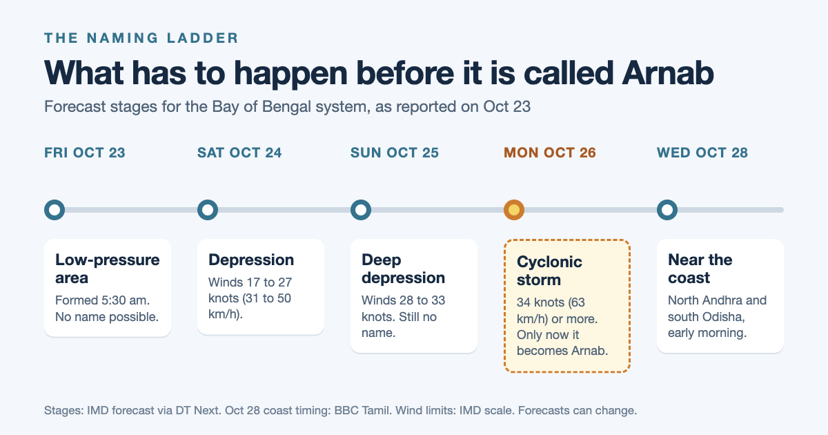
DT Next lays out one step a day. First, a depression on Saturday, Oct. 24. Then a deep depression on Sunday, Oct. 25. Then a cyclonic storm over the west-central Bay of Bengal on Monday, Oct. 26. After that, the IMD expects the system to move west-northwest toward the north Andhra Pradesh and south Odisha coasts.
BBC Tamil adds the timing for the coast. Citing the IMD, it says the system should approach the north Andhra Pradesh and south Odisha coast early on Oct. 28.
What the IMD says about rain and wind
BBC Tamil’s summary of the IMD forecast has the details below. It is one outlet’s summary, so I would treat the exact numbers as a guide and check the bulletin itself.
- Andaman Islands: heavy rain from Oct. 23 to 25.
- North Andhra Pradesh, Odisha and coastal West Bengal: rain starts on Oct. 26, and heavy to very heavy rain follows on Oct. 27.
- Oct. 28 and 29: very heavy rain in parts of north Andhra Pradesh and Odisha, with extremely heavy rain above 30 cm at one or two places.
- Gangetic West Bengal: heavy to very heavy rain on Oct. 28 and 29.
- At sea: winds of 55 to 65 km/h, gusting to 75 km/h, in the central and southeast bay on Oct. 24. From Oct. 25, winds of 70 to 80 km/h, gusting to 90 km/h, in the west-central bay.
- Fishermen: the IMD warns them to stay out of the sea, and those already out should come back.
Why Cyclone Arnab headlines showed up in September
This is the second time the name has been in the news in a month. In September, a depression headed for the same stretch of coast, and Republic World explained on Sept. 22 that the system was not Arnab. Arnab was only the next name on the list, and a storm would use it only after it reached cyclonic-storm strength.
The system then crossed the coast near Kalingapatnam in Andhra Pradesh between 11 p.m. on Sept. 23 and 1 a.m. on Sept. 24 as a deep depression, with winds of 55 to 65 km/h gusting to 75 km/h, Outlook Traveller reports. OdishaBytes reports that the IMD kept it at deep depression and ruled out Cyclone Arnab, while the U.S. Joint Typhoon Warning Center classified the same system as Tropical Cyclone 01B. In other words, two agencies used two different labels for one storm.
Still, it was not a quiet event. Odisha shut schools in districts such as Khurda and Ganjam, and Puri restricted sea bathing. In fact, a storm with no name still emptied classrooms. I would keep that in mind this week.
How a storm becomes Cyclone Arnab
Cyclone names are not made up on the day. A regional panel under the World Meteorological Organization keeps a list, and 13 countries contributed to it. Bangladesh gave Arnab, which means “ocean” in Bengali, according to Republic World. On Wikipedia’s roster, Arnab opens the third list, right after Ditwah, and India’s Murasu comes next.
| Stage | Sustained wind | Gets a name? |
|---|---|---|
| Depression | 17 to 27 knots (31 to 50 km/h) | No |
| Deep depression | 28 to 33 knots (52 to 61 km/h) | No |
| Cyclonic storm | 34 to 47 knots (63 to 88 km/h) | Yes, Arnab if it is next in line |
| Severe cyclonic storm | 48 to 63 knots (89 to 117 km/h) | Already named by this point |
The stage limits come from Republic World and Wikipedia’s table of the IMD scale. However, the point is simple: the name arrives at the cyclonic storm step, and the stages before it, including the one forecast for Sunday, come without one.
Here is my math on the timing. If the IMD’s Monday forecast holds, the name shows up on Oct. 26 and the system nears the coast early on Oct. 28. So that is about two days between the name and landfall, and five days from the first low on Oct. 23. As a result, anyone who waits for the name to start getting ready has roughly 48 hours.
Who gets rain before Cyclone Arnab arrives
Tamil Nadu is already wet. DT Next reports an orange alert on Oct. 23 for very heavy rain of 11.6 to 20.4 cm in 24 hours in Kanniyakumari, Nilgiris and Coimbatore, and a yellow alert for heavy rain in places including Chennai. Also, Chennai stays on the heavy rain list through Sunday, Oct. 25. Meanwhile, schools in Villupuram, Kallakurichi and Vellore closed on Friday, and Tiruvannamalai closed schools and colleges.
BBC Tamil also reported a fatal house-wall collapse in Virudhunagar district, and flash flooding that closed the Sathuragiri temple trail to pilgrims.
DT Next adds a detail that explains the crowded weather map. A second low that sat over the Comorin region and south Tamil Nadu moved over the southwest Arabian Sea, off south Kerala, on Friday morning. So two systems are in play. Still, my read is that Tamil Nadu is dealing with rain now, while Andhra Pradesh, Odisha and West Bengal are the places that should watch for the cyclone itself.
Cyclone Arnab safety: what to do before Oct. 26
I am not an emergency planner, so this list sticks to advice from official sources and the reporting around them.
If you live on the east coast
- Rely on official warnings only, and ignore forwarded messages. The Week’s summary of NDMA advice says the same.
- Likewise, keep your phone charged and a radio handy. The same NDMA list says to switch off the electrical mains and gas supply once the storm hits.
- Next, pack a kit now. My 3-day supplies checklist is written for the UK, but the logic is the same: water, food, a torch, medicines and documents in a waterproof bag.
- Learn the alert colors. Outlook Traveller’s guide lists yellow as “Be Aware,” orange as “Be Prepared” and red as “Take Action,” with red meaning extremely heavy rain above about 20 cm in 24 hours.
If you are travelling this week
Outlook Traveller’s September advisory is still the best checklist I found. First, check the latest IMD warning before you leave. Then skip beaches, rivers and hill roads during intense rain. Also ask your airline or railway before heading to the airport or station, because disruption can change at short notice. In September, Puri and Kolkata were the places it flagged for sea bathing limits and waterlogging.
Is Cyclone Arnab a big deal?
My take: the name is the least important part of this story. First, any headline that says “Cyclone Arnab has formed” before Monday is ahead of the facts. In September, the name ran in headlines for days over a system that never earned it.
But a missing name does not mean a mild storm. The September deep depression had 55 to 65 km/h winds and still closed schools. What I would watch is the rain forecast for Oct. 27 to 29 in north Andhra Pradesh and Odisha. BBC Tamil’s summary of the IMD says extremely heavy rain above 30 cm is possible at isolated places, and that number should drive decisions more than the label.
Finally, forecasts five days out can shift. If the track changes, the districts on these lists will change too, so I would recheck the bulletin each morning.
The short version
Cyclone Arnab does not exist yet: it is a Bay of Bengal low that the IMD says could become a named cyclonic storm on Oct. 26 and reach the north Andhra Pradesh and south Odisha coast around Oct. 28. Do not wait for the name to prepare, and follow the IMD rain warnings for Oct. 27 to 29.