Flash Flood Safety as Storms Sweep Eastern Australia
If you live anywhere between Brisbane and Hobart, flash flood safety is the most useful thing to read this weekend. South-east Queensland just had a week of record rain, and the forecasts say the storms are moving south. I read the Guardian, ABC and Nine forecasts this morning, then went through the official safety pages from the Bureau of Meteorology (BoM) and the state emergency services.
My read is simple. This time the main threat is rain more than wind, and the most dangerous place to be is a car on a road that looks like it has only a little water on it. Below is a day-by-day list, then the flash flood safety rules I would follow. I wrote this on Oct. 24, and storm forecasts change fast, so check the BOM Weather app for your own area.
Flash flood safety: where the storms go this weekend
BoM senior meteorologist David Crock told the Guardian that Saturday brings severe thunderstorms and heavy rain across central and eastern Queensland, including Rockhampton, Gladstone, Bundaberg, the Sunshine Coast hinterland and Roma. Parts of Victoria and South Australia get storms too. Here is how ABC meteorologist Tom Saunders laid out the next few days:
| Day | Where | Main threat |
|---|---|---|
| Sat, Oct. 24 | Central and south-east Queensland, plus a band of rain from South Australia through Victoria to Tasmania | Heavy rain and flash flooding in Queensland; storms in the south could turn severe |
| Sun, Oct. 25 | Central and eastern Victoria and much of NSW; supercells most likely over central inland and southern NSW and north-east Victoria | Flash flooding, damaging winds and large hail |
| Mon, Oct. 26 | Inland Queensland and north-east NSW, possibly tracking toward Brisbane later; SA, Victoria and Tasmania settle down | Severe storms, with supercells possible |
| Tue onward | Storms mostly pull back to the tropics | Models hint at another outbreak across central and south-eastern states later in the week |
The capital-city timing is the part I found most useful. ABC and Nine both say Sunday storms are most likely in Melbourne early in the morning, Canberra in the afternoon and Sydney in the late afternoon or evening. Brisbane gets another showery, thundery day, while Adelaide and Hobart stay wet without more thunderstorms. So in Sydney, the evening commute looks like the risky window. That is my inference, not something the sources said.
Why this week’s rain makes flash flooding worse
The BoM says flash floods happen within 6 hours of rain falling. They often follow short bursts of heavy rain, such as a thunderstorm, and they hit hardest where the ground is already saturated. That second part describes Queensland right now.
The Guardian reports that the Sunshine Coast hinterland and Caboolture recorded 300 to 400 mm over seven days, with some areas reaching 450 mm. ABC says rain has fallen across much of Queensland for 10 days in a row. Nambour logged 401 mm, its wettest October on record, and Beerburrum logged 354 mm, also a record. By my conversion, Nambour’s total is about 15.8 inches.
The human side is harder to read. On Thursday, the Queensland fire department carried out more than 16 swift-water rescues, including one where a raft was used to reach an elderly man clinging to the roof of his vehicle at Caboolture. Nine adds that one storm dropped almost three times the rain BoM had forecast for Thursday, in just a few hours.
That last detail changed how I think about warnings. If a forecast can miss by that much, it makes sense to treat any warning as the high end of what could happen. To be fair, ABC also notes the rain is welcome in general, because drought has developed this year on both sides of the border and bushfire season is close.
Flash flood safety in a car: the 15 cm rule
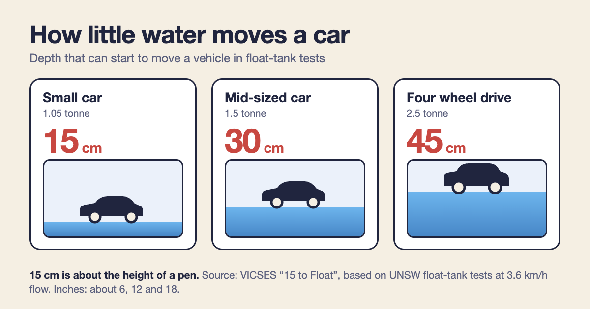
Victoria’s State Emergency Service runs a campaign called 15 to Float. It cites float-tank tests with real vehicles at the University of NSW Water Research Laboratory. The numbers are smaller than most people guess:
| Vehicle | Water depth that can move it | In inches (my conversion) |
|---|---|---|
| Small car (1.05 tonne) | 15 cm | About 6 in |
| Mid-sized car (1.5 tonne) | 30 cm | About 12 in |
| Four wheel drive (2.5 tonne) | 45 cm | About 18 in |
VICSES measured all three at a flow speed of 3.6 km/h, which is slower than a walk. It also points out that 15 cm is the height of an average pen. Fatalities involving 4WDs in floodwater have increased significantly over the last 15 years, according to the same page.
What the Queensland numbers say
Get Ready Queensland publishes the most detailed breakdown I found. Its figures on flood deaths on the road are worth reading slowly:
- 87% of lives lost happened on a creek crossing, bridge or causeway.
- Half of the fatal crashes happened at night on roads with little or no street lighting.
- Almost half happened within 20 km of the driver’s home.
Two more points from the same page. First, the “wading depth” in a car manual is meant for still or slow water, so it does not cover the dangers of floodwater. Also, newer cars are lighter and more buoyant, so they float more easily. A 4WD with a snorkel helps in some conditions, but Queensland says flooded roads are “in a category of their own.”
The number that stuck with me is this one: 12% of Queenslanders admitted to driving through floodwater on purpose in the past two years, while 15% said they entered it by accident. “Never drive through floodwater” sounds like advice for reckless drivers. Yet more people say they ended up in it by mistake than by choice. So good flash flood safety has to happen before the car moves. The state’s plan-ahead page says to check the forecast for where you are headed, check road conditions on QLDTraffic, and ask yourself whether you need to go right now. “Small delays can reduce big risks,” it says.
If water is already around the car
I could not find one official step-by-step guide for escaping a sinking car on the pages I read, so I will not invent one. Here is what the sources do say. Queensland warns that doors and windows can stop working in floodwater, and it suggests keeping an emergency hammer, a waterproof torch and a foil blanket within reach of the driver. Without a hammer, breaking a window is almost impossible, it adds.
For help, the NSW SES says to call 132 500 during storms and floods. In a life-threatening emergency, call Triple Zero (000). Its advice for a flooded road is plain: “turn around and find an alternative route or replan your travel for another day.”
How to read a severe thunderstorm warning
The BoM does not warn about every storm. As it explains on its severe thunderstorm page, it warns only about storms that reach a threshold:
| Rating | What triggers it |
|---|---|
| Severe | Hail of 2 cm or more (about 0.8 in), wind gusts of 90 km/h or more (about 56 mph), tornadoes, or heavy rain that could lead to flash flooding |
| Very dangerous | Giant hail of 5 cm or more (about 2 in), destructive gusts of 125 km/h or more (about 78 mph), tornadoes, or intense rain that could lead to dangerous, life-threatening flash flooding |
The mph and inch figures are my conversions. What matters is the shape of the list: one word, “severe”, covers four different threats. So when a warning lands on your phone, read which threat it names. ABC says the Queensland threat this week is heavy rain and flash flooding, not wind or hail. On Sunday in the south, it describes a “triple threat” of all three.
A few terms from the forecasts, in plain words. A squall line is a band of storm cells that cluster together, which lets the storm last longer and grow stronger (ABC). A supercell is the strongest type, with a deep, rotating updraft, and it can last for hours (BoM). The BoM also says Australia sees an average of 30 to 80 tornadoes a year, and most strong ones come with supercells.
For floods, there are two levels. A flood watch is early advice that developing weather could lead to flooding. A flood warning means flooding is likely or already happening (BoM). Still, the BoM admits that severe storms can be very local and can form and fade quickly, so the exact spot is hard to predict even a short time ahead.
Flash flood safety during the storm itself
The BoM’s own list, from its severe weather warning page, is short enough to remember. When a thunderstorm hits:
- Stay inside and shelter well clear of windows, doors and skylights.
- Skip the landline phone, because the wiring can carry electrical charges from lightning.
- Do not drive, walk, ride or swim through floodwater, and do not drive through water flowing over roads.
- If you are caught outdoors, move to a hard-top vehicle or solid building. The BoM says there is no safe place outdoors, and never to shelter under a tree.
- If you are swimming or surfing, leave the water immediately.
Before the storm arrives, the same page suggests tying down or storing garden furniture and trampolines, parking under solid cover and charging your phone. NSW SES adds clearing gutters and downpipes and trimming overhanging branches.
For alerts, the BOM Weather app lets you pick warning notifications for up to three locations. In NSW, the SES recommends the Hazards Near Me app with a watch zone for your area. In Victoria, VicEmergency works the same way. I would set one up today, because a storm that forms in minutes will not wait for you to download an app.
Melbourne: check the thunderstorm asthma forecast
Melbourne sits in the Sunday-morning storm window, and it is also grass pollen season. Victoria’s health department runs an epidemic thunderstorm asthma risk forecast from Oct. 1 to Dec. 31. It covers three days, uses green, orange and red ratings, and is published on VicEmergency. It combines a grass pollen forecast with a forecast of a certain type of thunderstorm.
People with current, past or undiagnosed asthma, or springtime hay fever, are considered at risk. For those people, the department says to avoid storms, especially the wind gusts that come ahead of them. Go inside, close windows and doors, and turn off air conditioners that bring in outside air. Keep a reliever on hand and know your asthma action plan. I could not read today’s rating, since it loads as a map, so check VicEmergency yourself. The department also stresses that a forecast is not a warning, and a green rating does not make an event impossible.
Flash flood safety for your wallet: insurance and clean-up
The Insurance Council of Australia explains that Australia has had a standard legal definition of flood since June 2012. It covers normally dry land that water has covered after escaping from a lake, river, creek or other natural watercourse, or from a reservoir, canal or dam. Flood cover itself comes in four forms: standard, standard with an opt-out, opt-in, or not offered.
Here is the part many people miss. Even if your policy excludes flood, it may still cover storm or rainwater damage. Some insurers will not cover rainwater runoff if you chose to skip flood cover, and your insurer may check how the water got into your home. My plain reading is that the source of the water decides which part of your policy applies. So read your product disclosure statement before you need it, and photograph any damage before you clean up. That second tip is mine, not the council’s.
One more warning for after the storm. The council’s help-in-disasters page lists a fact sheet on “disaster chasers” who knock on doors, claim to have spotted damage and offer quick repairs. It says they are often unlicensed and do non-compliant work.
My flash flood safety checklist for this week
None of this is complicated, and that is the point. Here is what I would do if I lived in the path of these storms:
- Today: set up BOM Weather notifications and a watch zone on Hazards Near Me or VicEmergency.
- Before any drive: check the forecast for your destination, not just your suburb, and check road conditions.
- On the road: avoid creek crossings, low bridges and causeways while storms are around, and never assume a road is safe just because no sign says it is closed.
- At home: secure loose items, park under solid cover and keep your phone charged.
- If a road is flooded: turn around, or push the trip to another day.
- This week: find your insurance policy and check how it treats flood and storm water.
I wrote a similar prep list for the UK’s Storm Boelo amber warning, and the basics overlap almost completely. Tie things down, charge your phone, stay off flooded roads. The Australian forecasts also hint at another round of storms later in the week, so I would keep the flash flood safety checklist handy.
The short version
Storms and flash flooding are moving from Queensland into Victoria, NSW and Tasmania this weekend, and the biggest danger is driving into water that looks shallow, because as little as 15 cm can move a small car. Set up your weather alerts, turn around at flooded roads, and read your insurance policy before you need it.